 |
|||||
 |
Virtual Reality
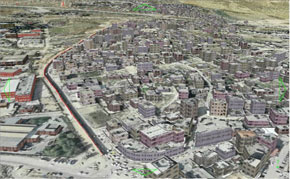
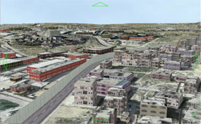
O Jerusalem* The aim of this project is to create a computerized tool dealing with the Jerusalem issue that will serve interested parties (governments, organizations, academic institutes, etc.) relevant to the Israeli-Palestinian conflict. The tool is designed for presentation and analysis of various aspects of the Jerusalem question, so as to enable decision-makers to better understand and outline well-informed policies regarding Jerusalem. The Environmental Simulation Laboratory of Tel Aviv University (ESLab) develops this computerized tool for, and in cooperation with, the Center for Middle East Peace & Economic Cooperation ? a non-governmental, non-profit, non-partisan, private organization, based in Washington, DC, and strives to promote a just resolution to the Israeli-Arab conflict, and with the support of the S. Daniel Abraham Center for International and Regional Studies. The ESLab?s development team includes Juval Portugali (Head of the lab), Asaf Roz (programming and software development), Dan Gonen (graphics), Erez Hatna, and other members of the ESLab. The representative of the Center in the development team is Dan Rothem. The computerized system is currently in its final stage of development. Using Skyline as its basic virtual reality (VR) engine, the software developed at the ESLab incorporates relevant Geographical Information System (GIS) components with a VR, three-dimensional application. The system allows for seamless, smooth interaction between vector themes produced by and existing on, GIS, and the corresponding VR environment. It further allows for high-quality, three-dimensional presentation based on aerial photos and topographical data; realistic presentation of the spatial elements (fences, walls, buildings, checkpoints, crossings, etc.). As illustrated below, the system allows the user to import existing GIS layers or create new ones, add a line, present it in 3D Virtual Jerusalem, transform the line into a fence or a wall, and then move (?walk?, ?drive? or ?fly?) in real time along the fence/wall and see how it affects the city and its inhabitants.
Watch a short demo movie of a virtual flight along the wall (avi) * "...upon thy walls, O Jerusalem..." (Isaiah 62:6) |
||||


