
| |
Back to Research Topics |
|---|
(with Itzhak Omer and Erez Hatna)
|
To introduce the actual heterogeneity of the city infrastructure and the differences between the citizens, we have implemented the agent-based model of residential dynamics in a GIS framework. |
|
|
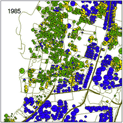
1:500 digital map of streets and houses of a section of Yaffo, Tel-Aviv, ~30000 population and ~3000 houses, presents the city infrastructure in the model. Migrating individuals have the ability to estimate the value of the house, the values of the neighboring houses and the characteristics of the neighbors, and behave in line with this information. They immigrate into the city, occupy apartments, and, when the conditions are unsatisfactory, either change location or leave the city at all. In parallel, the value of each house is changing in accordance with the mean status of its residents. Main model components |
| Geographic Information System
Representation and analysis of city spatial structure |
Spatial statistical analysis
Description and Analysis of emerging patterns |
| Israeli Central Bureau of
Statistics Source of data on persons and households |
High-Performance Computer (IBM
PS2) Fast processing of 10^6 householders and 10^5 households |
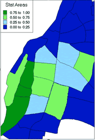
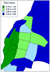
| Model screenshot and dynamics of the Jewish/Arab residential
distribution in Yaffo
at the level of statistical areas in 1995 in reality and in the model. |
 |
 |
 |
| Model screen shot, Blue - Jews, Green - Arab Muslems, Yellow - Arab Christians |
Yaffo Ethic Distribution in 1995, Fraction of Arab popualtion (Based on ICBS Census) |
Model Ethnic Distribution in 1995, Fraction of Arab population |
|
Back to Research Topics |
|---|