The unusual
merging of the Atlantic and African jet during winter 2009-10
The Atlantic
and Pacific zonal jet streams differ in character. While the Atlantic jet
meanders daily and interannually and is dominanatly eddy-driven, the Pacific jet is relatively
fixed at a latitude of around 35N, and is driven both by eddies and thermal
forcing from the tropics (Eichelberger and Hartmann,
2007; Li and Wettstein, 2012). In terms of the MQG model regimes, the Atlantic jet is an eddy driven jet,
while the Pacific jet is a merged jet. The reason we do not categorize
the Pacific jet as a subtropical jet is that it lies in the middle of
the Ferrel cell, and not at the subtropical edge of the Hadley cell (the
African-Asian jet, all the way to the Eastern coast of Asia is a subtropical
jet), as can be seen in the figure below:
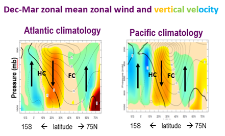
Figure 1: The
climatological Dec-Mar mean zonal wind (contours) and vertical velocity
(colors) zonally averaged over the Atlantic (left) and Pacific (middle)
sectors. The Hadley and Ferrel cells are marked by the letters HC and FC
respectively.
The North
Atlantic jet stream during winter 2010 was unusually zonal, so that the
typically separated Atlantic and African jets were merged into one zonal jet.
The latitude-height structure and temporal variability of the North Atlantic
jet during this winter were more characteristic of the North Pacific. The above
observations suggest that during winter 2009-10, the Atlantic jet underwent a
regime change from an eddy driven jet to a merged jet.
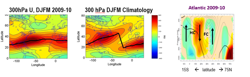
Figure 2:
Dec-Mar mean zonal wind at 300hPa over the North Atlantic region. Left- during
winter 2010. Middle- Dec-Mar Climatology. Right - the zonal wind (contours) and
vertical velocity (colors) zonally averaged over the Atlantic during winter
2009-10.
Harnik et al (2014) examines this
possibility of a regime transition by defining a Zonal Jet Index – ZJI – based
on the zonality of the jet axis (the thick black lines in the left and middle
plots of Figure 2 above). When the Atlantic and African jets are merged, this
line is anomalously zonal, and the ZJI is anomalously negative. The monthly ZJI
values are shown in Figure 3 below, with anomalously negative ZJI Dec-Mar
months marked by a solid black circle. We see that an anomalously zonal jet
state occurred in the past, but the winter of 2009-10 was unusually persistent.
Similar persistently zonal winters have occurred in the past at the end of the
1960s.
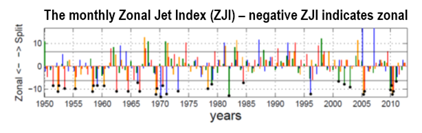
Figure 3: The
monthly Zonal Jet Index (ZJI), the with those Dec-Mar months with a ZJI less
than minus one standard deviation marked by a solid black circle.
Harnik et al
(2014) then examine the characteristics of anomalously zonal jet months using
composite analysis.
Consistent with
the results of the MQG model, the eddy fluxes during the years with a merged
jet were anomalously weak. In addition, diabatic heating in the tropical
Pacific was unusually strong. This combination of weak eddies in the North
Atlantic and strong tropical Pacific heating, act to push the jet towards a
merged eddy/thermally-driven state. We also find significant SST anomalies in
the North Atlantic, which reinforce the anomalous zonal winds, in particular in
the Eastern Atlantic.
This suggests the
following picture: while NAO variability during most years is a manifestation
of the meandering of an eddy driven jet, a small fraction of the most negative
NAO years are a regime transition to a merged jet state.